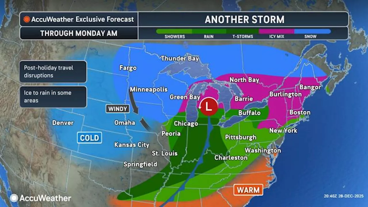
UPDATE: A powerful winter storm is sweeping across the central and eastern United States, raising urgent travel concerns and potential hazards as it intensifies into a bomb cyclone. AccuWeather reports that the storm, affecting over 24 states, will bring heavy snow, ice, severe thunderstorms, and winds exceeding 60 mph as it progresses through Monday night.
Meteorologist Brandon Buckingham warns, “This storm will create extremely dangerous travel conditions, particularly across the Great Lakes region.” The storm’s rapid intensification is expected to occur between Sunday afternoon and Monday afternoon, as it taps into moisture from the Gulf, impacting areas from Colorado to Maine.
Travel disruptions are anticipated to worsen as frigid air moves in, leading to potential whiteout conditions in the Midwest. Expect visibility to plummet to less than a quarter mile in open areas from southwestern Minnesota to central Ontario, triggering blizzard warnings. Accumulations of snow are projected to exceed 6 inches in some regions, alongside hazardous winds that may uproot trees and cause widespread power outages.
While the snow zone grapples with blizzard conditions, areas to the south will face a mix of rain, sleet, and freezing rain. The Northeast, particularly northern Pennsylvania through upstate New York, is on alert for significant icing, with potential accumulations of at least 0.25 inches, leading to treacherous road conditions. Buckingham cautions, “Even small amounts of freezing rain can create incredibly slick surfaces.”
In major cities along the storm’s path, rainfall could lead to hazardous travel conditions due to road spray, particularly for those driving near large vehicles. Rainfall will peak through the Midwest and Ohio Valley on Sunday night, moving eastward on Monday.
Adding to the storm’s complexity, severe thunderstorms with damaging winds and hail are forecast from the Ozarks to the Ohio Valley through Sunday night. Tornado risks exist in these areas, concealed by heavy rainfall, further complicating travel.
As the storm continues to develop, officials urge the public to stay informed and exercise caution. With forecasts indicating wind gusts of 40-60 mph affecting air travel, major airports, including those in Chicago, may experience significant disruptions.
Stay tuned for further updates as this urgent winter storm unfolds, impacting millions across the United States. Prioritize safety and stay updated on local forecasts and travel advisories.