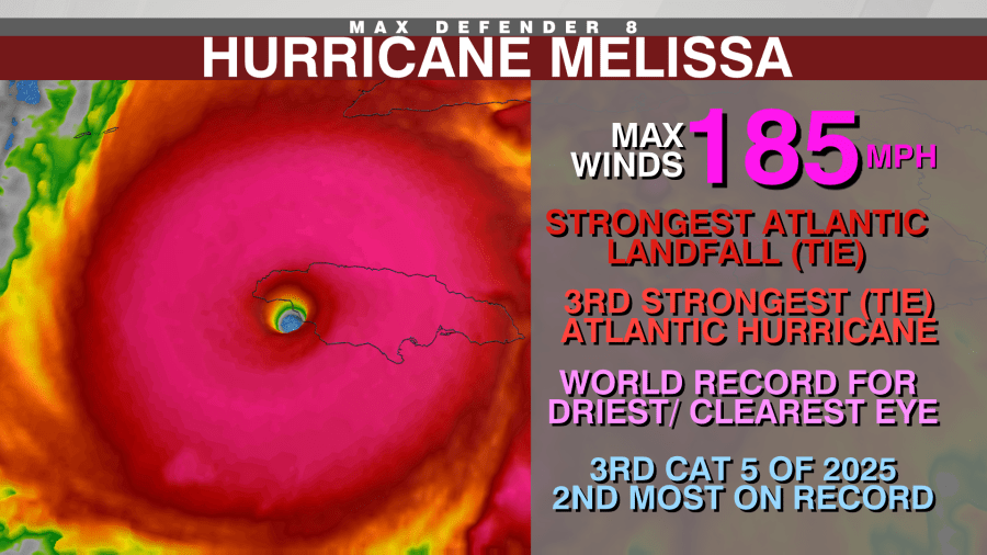
UPDATE: Hurricane Melissa has made history with an unprecedented landfall, now tied as the strongest ever recorded in the Atlantic, matching the infamous 1935 Florida Keys Labor Day hurricane. Both storms unleashed terrifying winds of 185 mph and a pressure of 892 mb at landfall, marking a significant moment in meteorological history.
This urgent update reveals more than just wind speeds; Melissa has shattered multiple records, including being the third strongest Atlantic hurricane on record and the world’s driest and clearest eye observed in such storms. It is also the third Category 5 hurricane of 2025, and tied for the fourth extreme rapid intensification episode this year.
Experts attribute Melissa’s explosive strength to its positioning over exceptionally warm waters in the Caribbean, which are 2-3 degrees Fahrenheit above recent norms. These conditions have created a potent energy source, fueling the storm as it moved through a region notorious for October hurricanes.
According to Jeff Berardelli, WFLA’s Chief Meteorologist, the ocean temperatures that powered Melissa are not just warm at the surface but extend deep into the ocean, providing an almost limitless supply of energy. “This warmer water is largely a result of manmade climate change, which has dramatically increased ocean temperatures over the last 50 years,” Berardelli stated.
Recent analyses by Climate Central underscore the impact of climate change on Melissa’s intensity, confirming that the hot conditions contributed to winds and rainfall that were significantly stronger than they would have been in the 20th century. In fact, the intensity of the hot water fueling Melissa was made 800 times more likely due to climate change.
As Hurricane Melissa continues to churn through the Atlantic, the implications of its unprecedented strength raise urgent questions about the future of storm patterns in a warming world. The storm’s intensity is estimated to be 10-15% more powerful than what would have been expected just a few decades ago.
The global community is watching closely as the storm develops. Authorities are urging residents in affected areas to remain vigilant and prepared for potential impacts. With the hurricane season still underway, experts warn that we may see more storms like Melissa if current ocean temperature trends continue.
Stay tuned for further updates as we continue to monitor Hurricane Melissa and its effects on the region. For real-time weather alerts and information, follow local meteorologists and official sources.