A severe storm complex is rapidly approaching the Tulsa metro area tonight with damaging winds, very heavy rain, and the possibility of a spin-up tornado, officials confirmed at 10:15 PM. Residents across Tulsa and surrounding communities are urged to seek shelter immediately as the dangerous storm system moves eastward toward the metro region.
Forecasters warn the primary threats from this storm are powerful straight-line winds capable of downing trees, snapping power lines, and causing structural damage. The storm is also dumping very heavy rainfall, which could rapidly flood roads and low-lying neighborhoods, creating hazardous travel conditions.
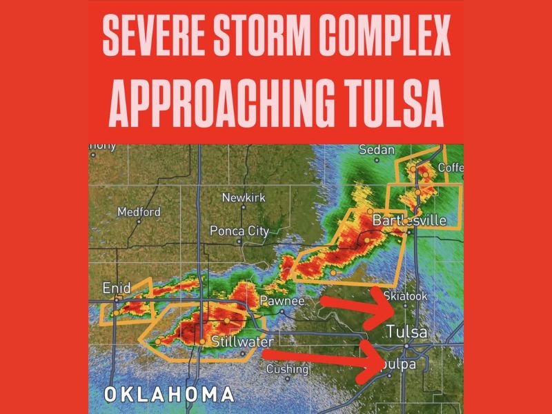
Storm Track and Immediate Impact Areas
As of 10:15 PM, radar data shows the storm complex stretching from near Enid, Oklahoma, eastward through Pawnee, Stillwater, and toward the northern suburbs of Tulsa including Skiatook. Two active warning polygons are targeting Tulsa directly, with a secondary track headed toward Sapulpa just south of the city. Barking to the north, Bartlesville is also under a tornado and severe thunderstorm threat with warnings currently active in that area.
The radar reveals intense red and orange storm cells moving directly into the metro area from the west and northwest, underscoring the immediacy of the threat to Tulsa residents. The highest risk corridor includes Skiatook, Tulsa, Sapulpa, and nearby suburbs — all expected to face the worst weather conditions over the next two hours.
Potential Tornado Risk and Safety Instructions
While damaging winds and flooding rain are considered the main hazards, National Weather Service forecasters have emphasized that a spin-up tornado cannot be ruled out in this rapidly evolving storm complex. Oklahoma residents must treat this event as a potential tornado-producing situation and take all precautions.
“Residents in Tulsa and adjacent communities should move to an interior room on the lowest floor of a sturdy building immediately,” the NWS advised, urging people to avoid windows and flood-prone areas.
No one in the storm’s path should wait for severe weather to develop before seeking safe shelter. Flood risks are high due to the intense rainfall, so drivers are especially warned not to attempt crossing water-covered roads to avoid life-threatening situations.
Ongoing Impact and Response
Several communities, including Stillwater, Pawnee, and Cushing, have already experienced severe weather as this complex moves east. With the storm now closing in on Tulsa, emergency services remain on high alert, and area residents are advised to monitor updates from local broadcasters and weather alerts closely.
Tulsa’s emergency management officials continue to urge vigilance as the situation unfolds within the next couple of hours. Power outages and infrastructure damage are anticipated given the strength of the storm.
Why This Matters to US and Alaska Audiences
Severe weather events in Oklahoma serve as critical reminders of the broader tornado and severe storm risks across the central and southern US—areas closely monitored by meteorologists from Alaska to Florida. They highlight the importance of preparedness nationwide, especially during peak storm seasons.
With the storm currently moving toward densely populated areas, the urgent call for shelter underscores the ongoing threats posed by climate-driven severe weather patterns. For Alaskans and US readers alike, tracking these developments reinforces the need for reliable warning systems and immediate community response.
The latest developments and warnings for this Oklahoma severe storm complex can be followed on regional news sites and official NWS channels. Tulsa residents should stay indoors and keep emergency supplies ready until the storm passes.